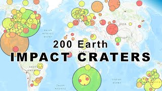
Mapping all 200 impact craters of the Earth Impact Database, Planetary and Space Science Centre
Keywords: Geography Viz, World Geography, Earth Impact Craters, Crater Size Classes, Crater Ages, Earth Impact Database, Planetary and Space Science Centre, Impact Craters Map
0:00 Intro
0:19 Carancas Crater
0:31 Haviland Crater
0:48 Kaali Crater
1:17 Douglas Crater
1:45 Boxhole, Aouelloul, Amguid, Monturaqui and Wolfe Creek craters
2:20 Barringer Crater (Meteor Crater)
3:28 Rotor Kamm Crater
3:40 New Quebec Crater
3:50 Gow Crater
4:17 Tin Bider Crater
4:28 Piccaninny Crater
4:42 Couture Crater
4:57 Connolly Crater
5:26 Spatial distribution of earth impact craters
5:57 Upheaval Dome Crater
6:10 Bosumtwi Crater
6:20 Gosses Bluff Crater
6:30 Haughton Crater
6:43 Ries Crater
6:53 Slate Islands Crater
7:03 Clearwater West Crater
7:14 Mjølnir Crater
7:33 Kara-Kul Crater
7:44 Manicouagan Crater
8:12 Sudbury Basin Crater
8:38 Chicxulub Crater
9:16 Vredefort Crater
9:54 Earth impact craters map
References & Photo Credits:
Earth Impact Database, Planetary and Space Science Centre. Accessed 2/1/2024. http://www.passc.net/EarthImpactDatabase/New%20website_05-2018/Index.html
Many Google Earth and NASA World Wind imagery screenshots
Carancas crater photo by Naturkundemuseum Berlin. https://www.meteorite-recon.com/home/meteorite-documentaries/carancas-meteorite
Kaali crater photo by wwikgren, 6/21/2016. https://www.flickr.com/photos/23227301@N00/27993548643/
Veski S, Heinsalu A, Kirsimäe K, Poska A & Saarse L (2001) Ecological catastrophe in connection with the impact of the Kaali meteorite about 800–400 BC on the island of Saaremaa, Estonia. Meteoritics & Planetary Science, 36, 1367-1375.
Mö NA (2020) The Kaali impact as trigger of a mega-tsunami event and violent seismotectonics in Sweden. International Journal of Astronomy and Astrophysics, 10, 235-246.
Kenkmann T, Sundell KA. & Cook D (2018) Evidence for a large Paleozoic impact crater strewn field in the Rocky Mountains. Scientific reports, 8, 1-12.
Amguid Crater photo by B Devouard. https://commons.wikimedia.org/wiki/File:CratereAmguid.jpg
Monturaqui Crater photo by RudiR https://commons.wikimedia.org/wiki/File:Monturaqui.jpg
Wolfe Creek Crater photo by enet_gre. https://greenhillmigration.com.au/sights-to-see-in-australia-wolfe-creek-crater/
Kring DA (2007) Guidebook to the geology of barringer meteorite crater, Arizona. Houston: Lunar and Planetary Institute.
Rotor Kamm Crater photo, O Ernst, 26 Apr 2017. https://commons.wikimedia.org/wiki/File:Roter_Kamm_Bird%27s_Eye_View.jpg
New Quebec Crater photo, courtesy of D Sarrazin, 12 Oct 2007. https://earthobservatory.nasa.gov/images/79743/ice-free-crater-lakes-on-ungava-peninsula
NASA image of simple and complex craters https://commons.wikimedia.org/wiki/File:Craterstructure.gif
Tin Bider Crater imagery NASA Earth Observatory Image of the Day, Dec 19, 2010 (Instrument: EO-1 — ALI). https://earthobservatory.nasa.gov/images/47939/tin-bider-crater-algeria
Neville AS, Cook DJ, Afifi AM & Stewart SA (2014) Five buried crater structures imaged on reflection seismic data in Saudi Arabia. GeoArabia, 19, 17-44.
Cratonic Regions Map https://www.athenapub.com/aria1/PAL/craton1.html
Gosses Bluff Crater photo https://www.reddit.com/r/australia/comments/9ctcag/an_impact_crater_in_the_northern_territory_gosses/
Haughton imagery is TanDEM-X elevation model provided to Earth Impact Database by Manfred Gottwald
Haughton shatter cone photo modified from Fig 2 of Osinski GR & Spray JG (2006) Shatter cones of the Haughton impact structure, Canada. In First International Conference on Impact Cratering in the Solar System.
Ries Crater photo by Wolkenkratzer, 10 Jul 2016. https://commons.wikimedia.org/wiki/File:N%C3%B6rdlingen_009.jpg
Dressler BO, Sharpton VL & Copeland P (1999) Slate Islands, Lake Superior, Canada: A mid-size, complex impact structure (No. Special-Paper-339). Geological Society of America.
Manicouagan Crater imagery https://www.myscience.org/news/2023/des_chercheurs_decouvrent_le_lac_le_plus_profond_du_quebec-2023-ulaval
Sudbury basin imagery https://earthobservatory.nasa.gov/images/148844/sudbury-impact-structure
Sudbury basin cross-sections https://craterexplorer.ca/sudbury-impact-structure/, initial source Ontario Geological Survey
Sudbury basin cross-section https://commons.wikimedia.org/wiki/File:Sudbury_Basin_Non-Ferrous_Metals_-_Eastern_Canada_map.png
Chicxulub imagery https://commons.wikimedia.org/wiki/File:Yucatan_chix_crater.jpg
Impact artistic rendering (NASA) https://commons.wikimedia.org/wiki/File:Impact_event.jpg
K-T-boundary rock image from https://commons.wikimedia.org/wiki/File:K-T-boundary.JPG
Allen NH, Nakajima M, Wünnemann K, Helhoski S & Trail D (2022) A revision of the formation conditions of the Vredefort crater. Journal of Geophysical Research: Planets, 127, e2022JE007186.
 26:44
26:44
 25:03
25:03
 13:32
13:32
 1:06:00
 25:17
25:17
 18:45
18:45
 32:15
32:15
 26:49
26:49
 15:01
15:01
 49:12
49:12
 27:15
27:15
 45:53
45:53
 45:59
45:59
 10:58
10:58
 17:21
17:21
 48:46
48:46
 19:41
19:41
 24:09
24:09
 48:01
48:01
 33:45
33:45


